Introduction.
The History of a country or a society is written on the basis of archaelogical evidences and not on beliefs. As a result, Shri Ram, sadly, due to the lack of any scientific evidence is at times called as mythological personality. This undoubtedly causes distress to millions. If we rely only on faith, and do not look for scientific evidence we will be doing grave injustice to a great personality who walked through the Indian jungles obeying his father’s dictat, helping Rishis and giving justice to many. He was truly an epitome of Virtue and inspired billions over many generations.
Although one can go on and on to explain and justify his existence that ; Shri Ram’s description exists in Puranas etc , the places related to Shri Ram’s life as described in Valmiki’s Ramayan exist even now, but they cannot be considered as scientific evidence . The fiction writers also use the names of streets and cities as they exist but the characters they mention in their novels do not exist in real life.
So, after hundreds and thousands of years of destruction caused by floods, earthquakes and invasions, gathering evidence which may stand the test of science relating to Shri Rama’s life would be very difficult, BUT NOT IMPOSSIBLE.
Notwithstanding the above, a dedicated team of researchers can still find him because ;
“Nobody believed that Homer's Iliad was a true story till Troy was discovered after extensive archaeology.
So we should not stop the quest and rather work with a scientific aptitude and doggedly to look for evidence.
Can Astronomical evidence work .
Some astronomers have identified the approximate time of the Ramayana by the description of the stars and constellations as given in the Ramayana, or even in the Bhagavata Purana and other texts. One such Book is written by Mr Pushkar Bhatnagar, titled ; Dating the Era of Lord Rama.
He claims that there is a significant amount of astronomical evidence available to prove that Rama was a historical personality. He says, “Valmiki, who wrote the Ramayana, was a contemporary of Rama. While narrating the events of the epic, Valmiki has mentioned the position of the planets at several places, which can easily be verified using software. Since the planetary configurations do not repeat for hundreds of years and cannot be manipulated or imagined so accurately, without the help of sophisticated software. The inference that one can draw is that someone was present there to witness the actual happening of these configurations, which got recorded in the story of Rama."
Mr Bhatnagar provides the following quote from the Ramayana: “Rama was born on the Navami tithi of Shukla Paksha of Chaitra masa (9th day of the increasing phase of the moon in the lunar month of Chaitra). At that time, the nakshatra was Punarvasu, and Sun, Mars, Saturn, Jupiter and Venus were in Aries, Capricorn, Libra, Cancer and Pisces respectively. Lagna was Cancer and Jupiter & Moon were shining together. — Ramayana 1.18.8,9
He claims that By using a powerful planetarium software, he found that the planetary positions mentioned in Ramayana for the date of birth of Shri Ram had occurred at around 12.30 p.m. of 10th January 5114 BC. It was the ninth day of the Shukla Paksh of Chaitra month too. Moving forward, after 25 years of the birth of Shri Ram, the position of planets in the sky tallies with their description in Ramayana. Again, on the amavasya (new moon) of the 10th month of the 13th year of exile the solar eclipse had indeed occurred and the particular arrangement of planets in the sky was visible. ( Date comes to 7th October, 5077 BC). Even the occurrence of subsequent two eclipses also tally with the respective description in Valmiki Ramayana. (Date of Hanumanji’s meeting Sitaji at Lanka was 12th September, 5076 BC). In this manner the entire sequence of the planetary positions gets verified and all the dates can be precisely determined.”
The date of war 5114 - 39 = 5075 BC
But even this does not become scientific evidence because may be Valmiki an astronomer himself in order to make his story appear true used these constellations.
However, this can be used as perhaps circumstantial evidence .
So, what could serve the purpose? If we are able to lay hand on one of the following items related to Shri Ram, I think it would make our task easier;
- Sitaji’s Chudamani that she gave to Hanumanji as an evidence.
- The ring that Shri Ram gave to Hanumanji to give it to Sitaji on which Ram was written.
- The Metal parts of weapons that were used by the two armies that could be found in the area where battle was fought for days.
- The metal parts of chariots that were used by Ravana.
- Some rock inscriptions of that era describing the war.
- Sitaji’s ornaments that Sugreev showed Shri Ram.
- The skeletons of soldiers who fought in that war might be found in the largely virgin jungles of Srilanka.
Locating Evidence.
A civilization cannot suddenly burst into advanced writing. So, One needs to look at various sources of history to re-build it. Especially when looking at ancient history. Thence Puranas, Mahabharat etc which describe the existence of Shri Ram AND WRITTEN IN DIFFERENT TIMES are surely a circumstantial evidence. Because all these texts indicate that the Ramayana is geographically very correct. Every site on Shri Rama's route is still identifiable and has continuing traditions or temples to commemorate Rama's visit.
Hundreds of years ago, no writer had the means to travel around the country inventing a story and thereafter fitting it into local folklore. Yes, those sites might have got the importance subsequently like it happened in case of Jesus ; All those places associated with Jesus were identified once the Roman King adopted Christianity and his mother came down to Jerusalem looking for various artifacts and identify places linked to Jesus, almost after 40 years of his crucification .
Therefore, an argument that Shri Ram was not worshipped in Ashoka's times and came to be worshipped only in 10th century or so is a bogus one. Shri Ram was not a Saint or a Swamy who had started a sect or a Panth, obviously, it would have taken time for people to fathom and realise the enormity of his achievements, because he was a King and not a preacher..
There have been many researchers who have visited all the places that Shri Ram visited during his exile as mentioned in Valmiki’s Ramyana. One of them is Dr Ram Avtar.
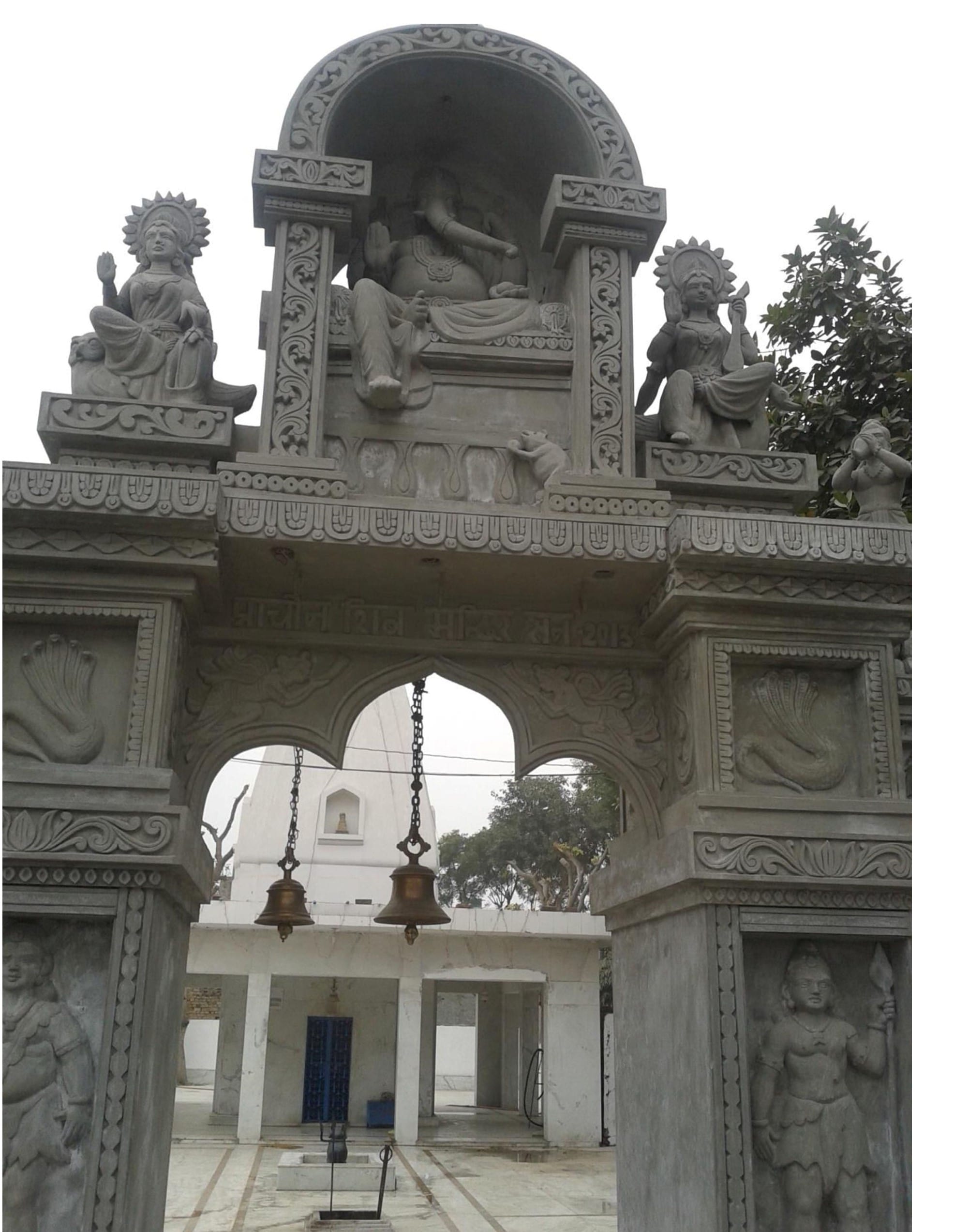
I have also visited many sites associated with Shri Ram including the birthplace of Ravan. It is believed that Ravan was born at Bisrakh , now a small village near Greater Noida. There is still a small Shiv temple where it is beleived that Ravan's father was a priest.
Shiv Temple at Bisrakh , believed to be of Ravan's Father Vishravas . The name of this village - Bisrakh, it is said has been derived from ; Vishravas.
Below is the ancient Shivji's Temple where Ravan's father was believed to be the Priest.
Dr Avtaar sequentially moved to all the places as stated in the Valmiki’s Ramayan. Starting from Ayodhya, he went right upto Rameshwaram and Srilanka . He found 195 places which still have the memorials connected to the events relating to the life of Shri Rama and Sitaji and the locals believe that Shri Rama had actually visited these places. Ayodhya Kand, Aranya Kand, Kishkindha Kand and Sunder Kand give in great details the account of these places which mostly included Rishi ashrams located along several river banks. These details can be divided into 5 phases.
1st Phase –Shri Ram went to Tamsa Nadi Tal (Mandah) – 20 km from Ayodhya, thereafter crossed Gomti river. Then they reached Ganges and entered Shringverpur (Singraur) which was kingdom of Nishadraj Guh and is famous for Kewat prasang (20 km from Allahabad). After crossing Yamuna near Sangam they reached Chitrakoot on UP and MP border - memorials include Valmiki Ashram, Mandavya Ashram, Bharat Koop etc. still exist. Thereafter they went to Atri Ashram located in Satana in MP.
All these places, although the locals believe that Shri Ram visited, but hardly anything worthwhile can be found.
2nd Phase in Dandak Van. Shri Rama travelled through this land of rivulets and water bodies and dense forests around MP and Chhatisgarh. They roamed around in Dandak Aranya area and visited several Rishi ashrams in MP and Chattisgarh areas, along Narmada and Mahanadi rivers for 10 years. Several memorials in Panna, Raipur, Bastar and Jagdalpur still exist which include Mandavya ashram, Shringi ashram, Ram Laxman Mandir etc. Thereafter, they REACHED Agastya ashram in Nasik. As per Valmiki, weapons made in Agnishala were given to Shri Rama by Agastya Muni in this ashram.
Once again nothing worthwhile can be found here also.
3rd Phase Shri Rama, Laxman and Sitaji travelled along Godavari. From Agastya ashram they went to stay in Panchvati. This place is famous for Shroopnakha episode . Nasik area is full of memorials; Sita Sarovar, Ram Kund and Triambakeshwar and Janasthan etc. , Sitaji was abducted by Ravana from here, who also killed Jatayu— memorial ‘Sarvatiratha’ in Taked Village, 56 km from Nasik, is still preserved.
Once again, none of the memorials can be termed as scientific evidence.
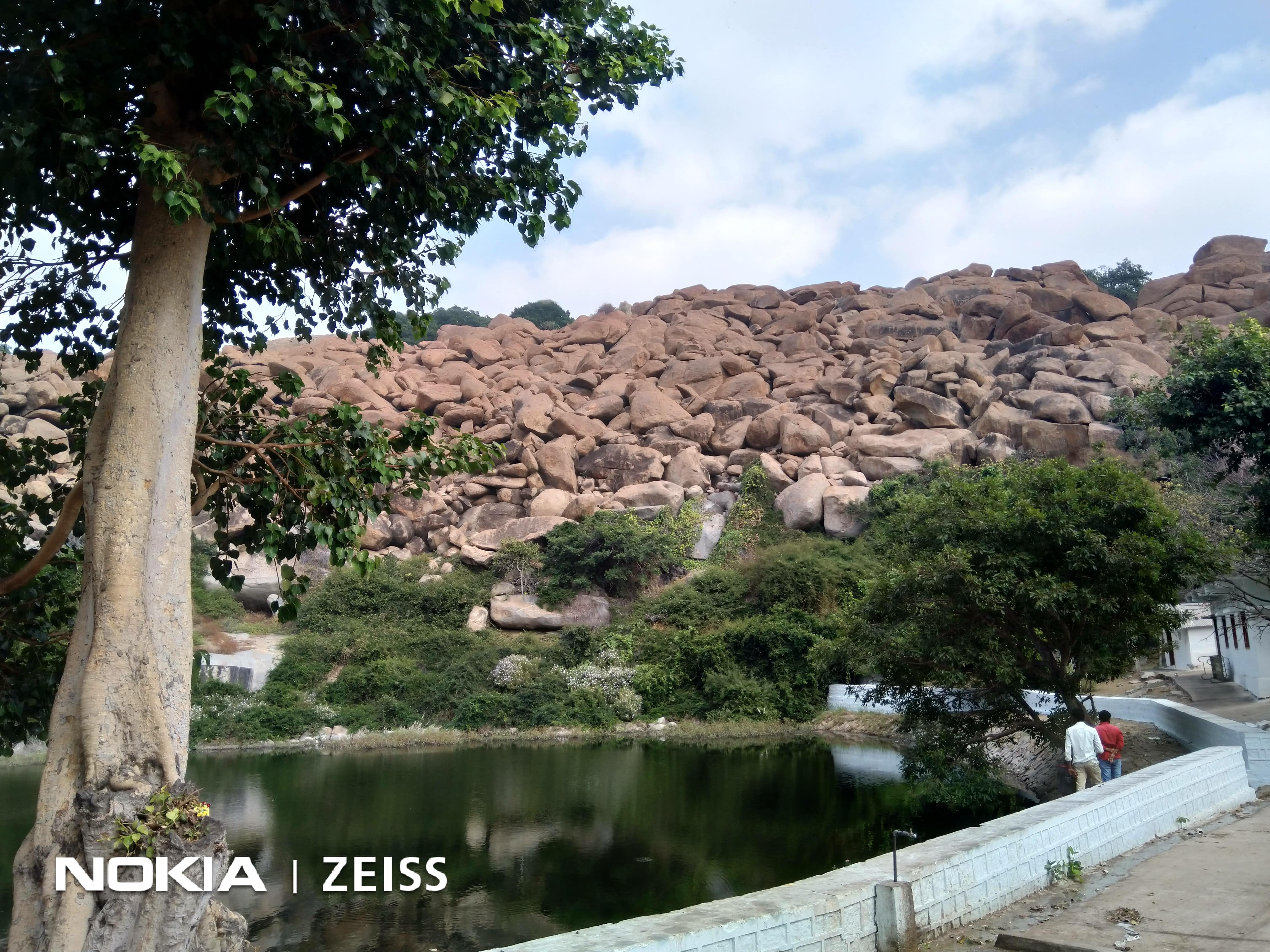
4th Phase along Tungbhadra and Kaveri. Shri Rama and Laxman extensively travelled through these areas in search of Sitaji. After meeting Jatayu they moved towards south to reach Rishyamook Parbat, in Hampi. Entire Sundarkand is based on this area. Enroute, they visited Shabari ashram in Pampasarovar area in Belgaon and is still famous for Ber trees. There is another Pampasarovar in Hampi which is also claimed to be Mata Sabrees’ ashram. This one makes sense as it is closer to Rishyamukh Parbat and Rishi Matang's ashram who was the Guru of Mata Sabree. Moreover, as it was Mata sabree who directed Ram to Hanuma/Sugreev who were residing close to her Ashram. After crossing forests of Sandalwood, gardens and water bodies, they went towards Rishyamook. Here they met Hanumanji and Sugreev, and were shown Sitaji’s ornaments. Shri Rama killed Bali in this area. Rishyamook and Kishkindha are located in Hampi, Distt. Ballari of Karnataka.
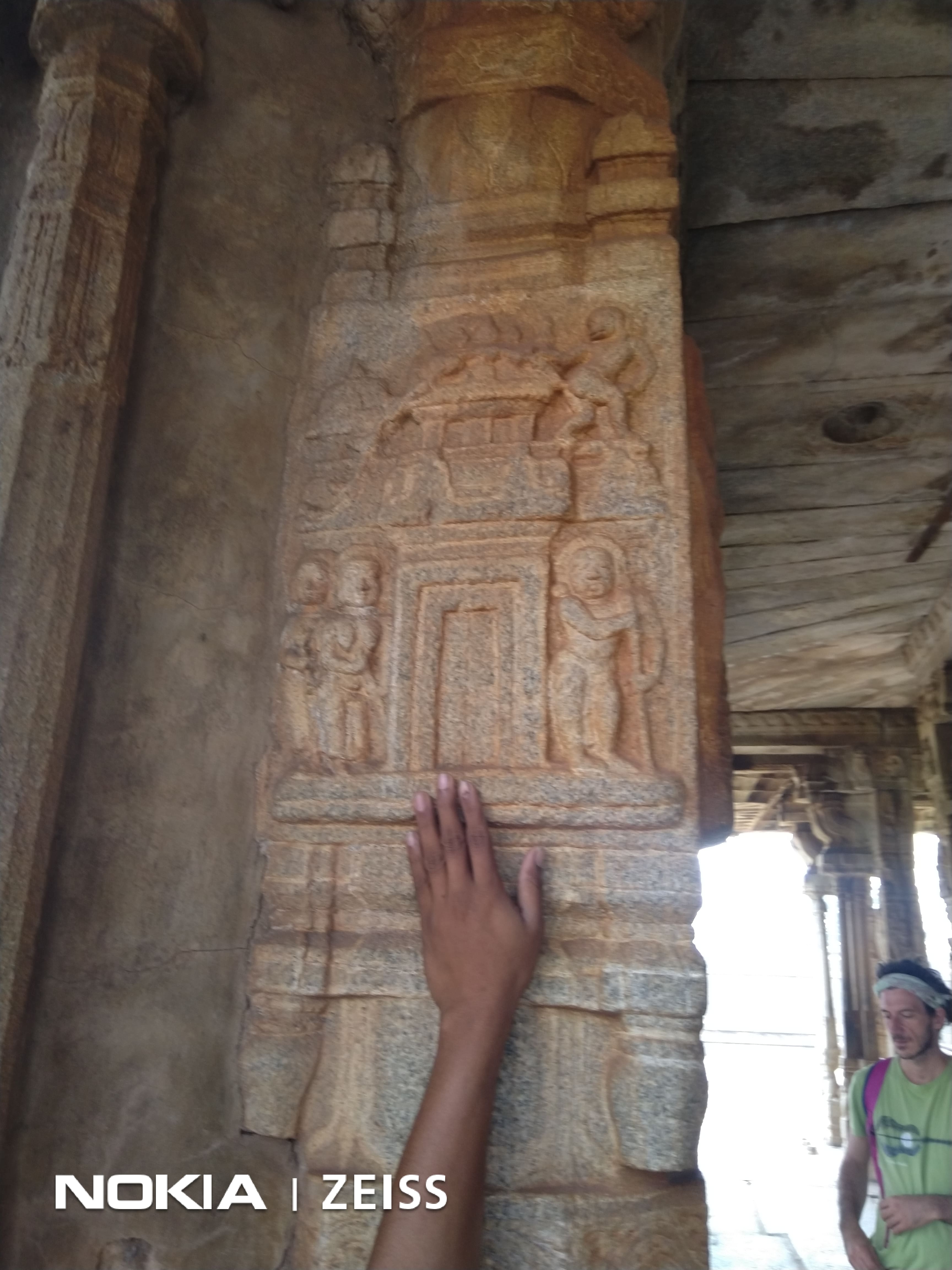
Shri Ram and Hanumanji have been in the folk lore for many centuries and one can see stories from Ramayan engraved in the columns of many temples of the Vijaynagar empire. There are also many memorials associated with Ramayan mentioned in Kishkindha Kand are located here ; Rishi Matang Ashram, Pampasarowar, Anjaniya Hill, Malyawant Ram temple etc.
But once again nothing worthwhile which can scientifically establish the existence of Shri Ram can be found here.
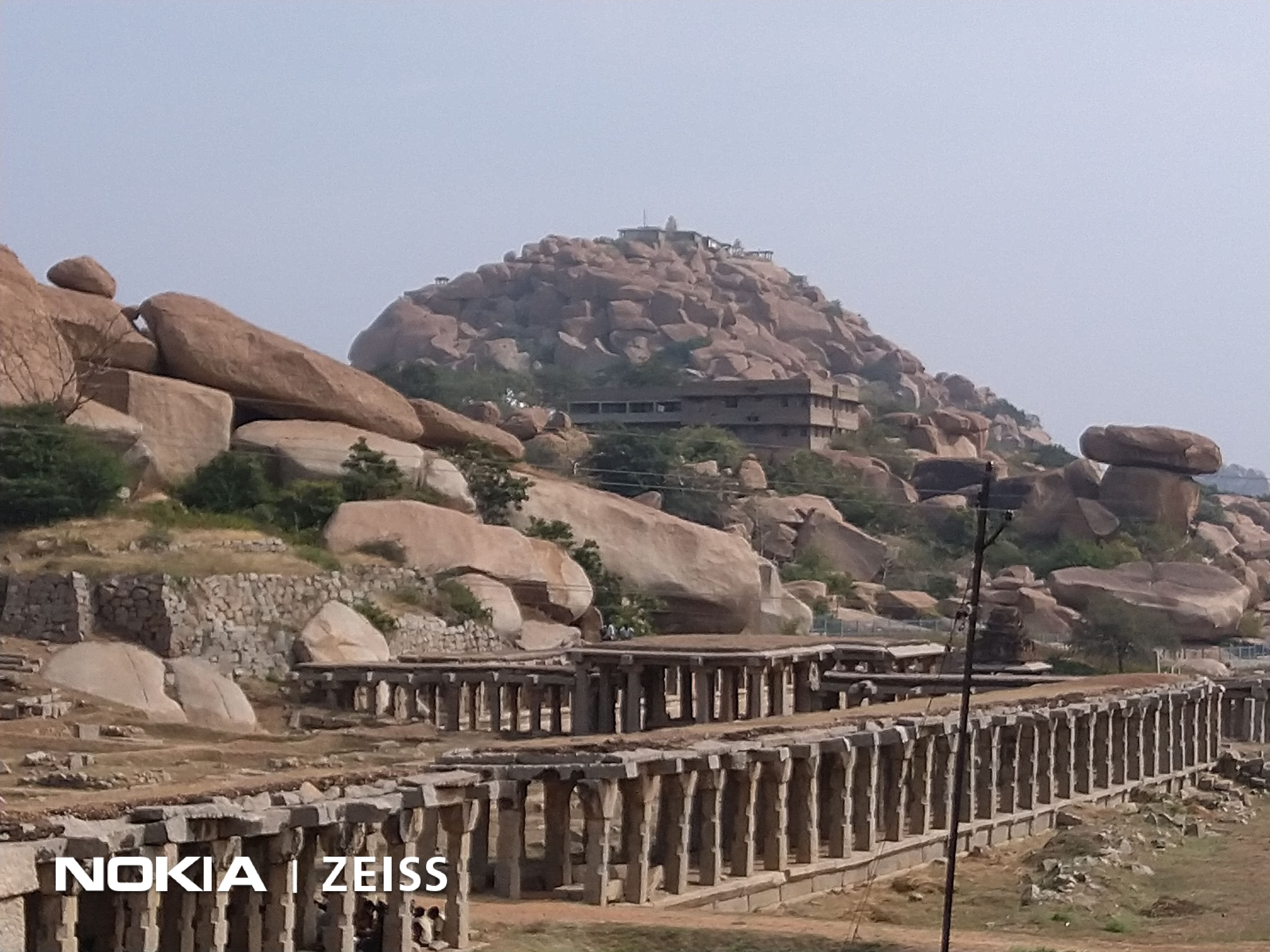
Ram Temple at Malyawant Hill ; Here on this Hill Shri Ram and Laxman spent the monsoons before proceeding to Lanka.
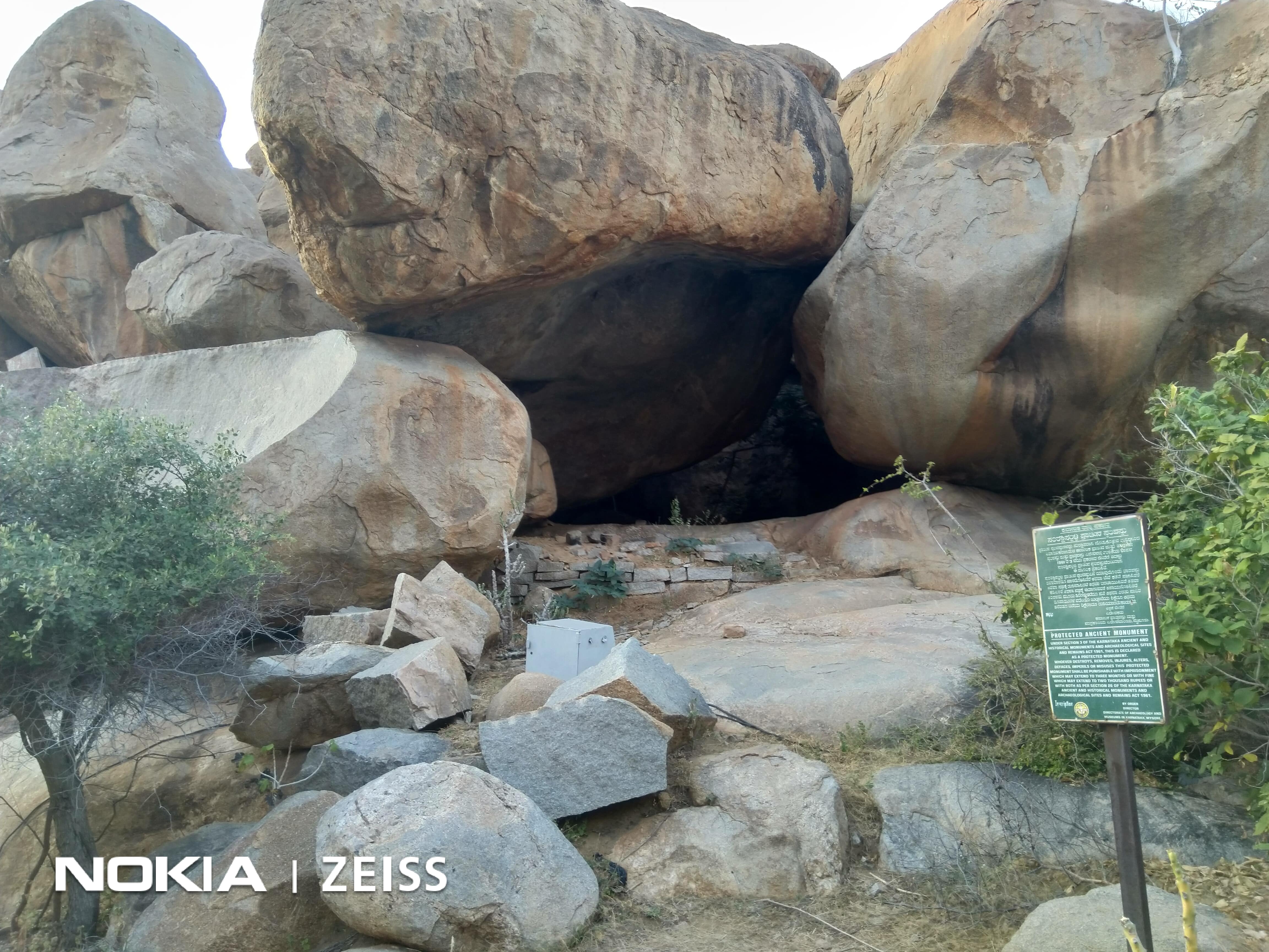
Rishi Matang's Ashram on Matang Hill.(Guru of Mata Sabree and the one who had cursed Bali, Sugreeb was hiding in a cave near this Hill)
Anjananya Hill ; Birthplace of Hanumanji near Hampi
Pampasarovar where Mata Shabree Ashram is located ; She directed Shri Ram and Laxman towards Rishimookh Parwat where Sugreev was hiding. This is adjoining Rishi Matang's Ashram on Matang Hill.
Sugreev Cave where Sugreev was hiding in fear of his brother Bali who was cursed by Rishi Matang.
Hanumanji Burning Lanka engraved on a column of a temple located amongst the ruins of Vijaynagar Empire.
Ruins of Vijaynagar Empire and in the background is Rishi Matang's Ashram on the Hill.
5th Phase In this Phase Shri Rama with his sena marched towards the sea, constructs the bridge and crosses the sea. Details of travel narrated in Valmiki’s Ramayan tally with the existing memorials. It is said that after surveying the place for three days, suitable area was identified and the bridge was constructed under the supervision of great shilpakar Nal. In Rameshwaram, particularly from Dhanushkoti, the boatmen still take visitors in boats to show remains of Shri Rama’s bridge, called as Ram Sethu, but it is considered fashionable to call it Adam’s bridge instead of calling it by its historical name i.e. Ram sethu.
But even this bridge is of little help as of now, till some scientific research proves that it is man made and gives us the date of its construction. Although there are many old maps available to show that there was a land link between Rameshwaram and Mannar but till the time we do not hear from scientists that the land link that is now submerged is man made , we can not use this as an evidence.
However, there is nothing to feel sad about it because there is Phase 6 , where , we can get lot of evidence, if we toil hard in specific areas as enumerated in subsequent paras.
Sixth Phase is the final Phase where Shri Ram crosses over to Lanka and fights a war. Srilanka therefore has a special significance in Ramayana. Valmiki has mentioned a few areas where Shri Ram stayed after crossing over in Yudh Kaand and also in Sundarkand. Lastly as Ravan is a revered king in Srilankan history and in some parts Vibhishan is also revered there are numerous places associated with both of them which are mentioned in the folklore of Lanka.
Although no archaeological evidence might have been found till now to prove the veracity of story as narrated by Valmiki but Srilanka was the land of two principal characters; Ravana and Vibishana of Ramayana and we can not undermine the importance of folk lores related to Ravan and Vibhishan in this part of the world.
Moreover, if nothing of archealeogical importance been found till now it is not necessary that It can never be found.
Srilanka has not witnessed the kind of invasions And destruction that India has faced and the jungles in Srilanka are pretty dense and largely unexplored , there is a strong probability of finding something in those jungles .
We must have a large heart and a strong will to search for evidence here in the areas as described below because if thousands of year old skeletons and fossils of animals have been found at several places in the world, we can surely lay hands on skeletons of soldiers or metal pieces of weapons used by soldiers of the two armies in Srilanka, provided we look for them in Right areas..
For this reason, It is important that we discuss the Places of Phase 6 of Ramayana (Shri Ram in Srilanka) in little more details and we may be able to find a few evidences of the battle that was fought thousands of years ago.
Ravana has gained more prominence in popular Sinhalese culture .
Sri Lankan lore has it that Sri Lanka was once ruled by the scholarly Ravana and it saw great advancements in science and medicine. The pushpaka vimana or the aeroplane which he flew is held as an example of great scientific achievements made during his regime while Ravana also holds a high position as a physician and it is said that he wrote seven books on Ayurveda . He is also believed to have authored Ravana Sanhita, an anthology of Hindu astrology, also invented a musical insturment ; Veena. His description as a ten-headed person, Daśamukha or Daśagrīva, is believed to be a reference to his vast knowledge and intelligence.
His Kingdom had mainly concentrated around the Eastern and Southern corners of the country and believed to have been lost to the sea with the years.
The Srilankans hold Ravan in such great esteem that they have named their first satellite as Ravana.
Now, how could Valmiki or Brahmins achieve this feat in Srilanka is unexplicabe.
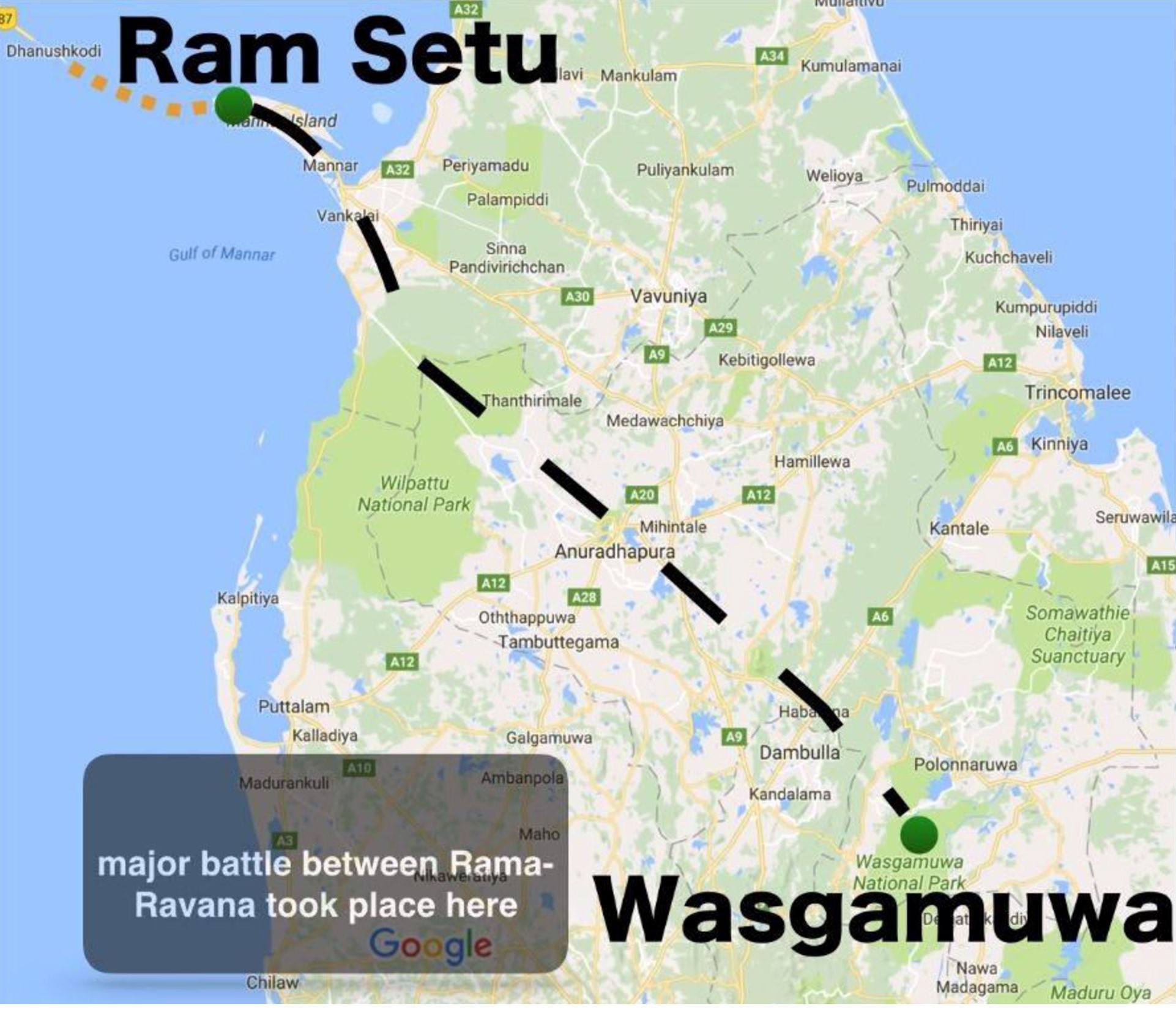
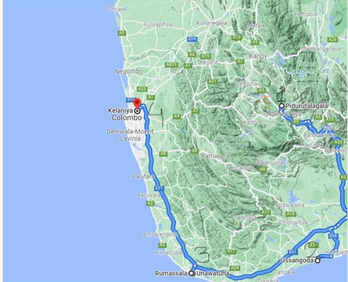
The Advance to Ravana’s Kingdom
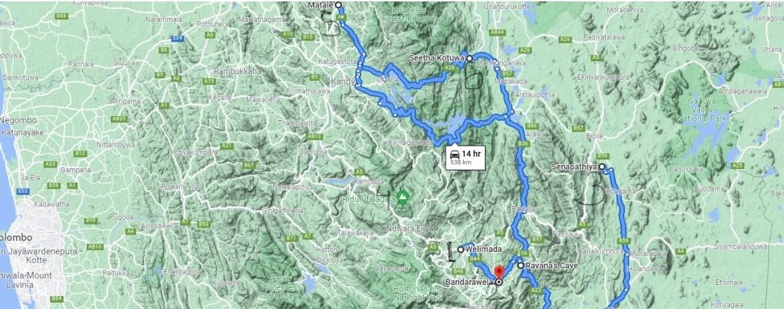
After crossing the Bridge Ram Sethu, Shri Ram would have landed at present day Mannar thereafter he had two options as Hanumanji would have given him clear idea of where Sitaji was kept ; A place now called as Seeta KOTUWA , she was subsequently shifted to Nuwara eliya after Hanumanji’s visit.
Option 1 ; Western approach - Mannar – Vankalai- Pomparippu-Puttalam-Wariyapola-Laggagala(this was the place where Ram’s army was sited first by Ravana) this comes to approx 336 kms.
Option 2 – Northern approach . Mannar – Mihintale-Laggala, this comes to approx 250 kms almost 80 kms shorter.
.
Clues from the Terrain.
As we look at the map and assess the sites/places that are associated with Ravan even in Sri lankan folk lore the following clearly stands out.
One. The Most important structure that can provide the evidence , is the RAM SETU, Believed to have been constructed by Shri Ram's army. The National Institute of Oceanography has now taken up this project of studying the Ram Setu scientifically and it is hoped in Next THREE YEARS we would get a Report.
Two. Any infantry advancing through an unknown enemy’s country would avoid to walk with a huge obstacle on one side, hence it is unlikely that Ram would have preferred to take option 1 and walked alongside Sea, hence he would have taken the northern approach i.e Option 2 as shown below. Using dense forest cover to hide his advancing force and moved Bound to bound i.e moving from one dominating feature to another one. and might have made one huge secured dominating feature as their Firm Base, from where they could send out the recce parties to assess the enemy's strenght and his deployment. Given the Range of weapons and equipment that they had , their Firm base should have been a dominating feature from where they could observe and protect their troops.
MAP 1.
Three. The south-central part of Sri Lanka is a rugged high land that appears to be the heart of the country. The core of this area is a high plateau running north–south for approximately 65 kilometers. This area includes Sri Lanka's highest mountains ; Pidurutalagala is the highest at 2,524 m) At the plateau's southern end, the mountain ranges stretch 50 kilometers to the west toward Adam Peak (2,243 meters) and 50 kilometers to the east toward Namunakula .
Four. Thus these mountains would have served a natural def barrier as Hindukkush and Himalays served to Indian subcontinent. But the commercial centres must have been in plains down south. However, Ravan would have had big forts in the central portion of the plateau and sentry posts towards North on dominating heights. Moreover, in ancient times the size of Kingdoms used to be smaller, at times they used to be CITY KINGDOMS.
Five. From Mannar to Mihintale is approx 131 kms. The terrain till Mihintale is plain and Mihintale might be the first Dominating feature his army would have found.
This was also the Rock where once Prince Mahindra, Emperor Ashok’s son and Srilankan king Devanapiyatissa had met for the first time . It is quite likely that this rock had some importance even in 300 BC for the kings to meet and there were some stairs to climb the rock would have already existed.
To cover 131 kms , Shri Ram’s army should have taken atleast 4 days to reach Mihintale . and as they occupied a high ground after crossing over into the enemy territory , they must have felt secured and hence worthy of description in Valmiki’s Ramyan .
Hence can Suvel Parvat(Described in Valmiki’s Ramayan in Ramayan) be the same rock at Mihintale. At the foot of the mountain are the ruins of a hospital, medical bath (or stone canoe in which patients were immersed in medicinal oil) a stone inscription and urns belonging to the ancient period have been unearthed. This proves the ancient importance of the Rock.
However, in Ramayan(Yudh Kaand) there is a description that Shri Ram could see the lights of Ravan's palace from Suvel Parvat where Ravan's dancers adored with precious jwellery were performing on such a huge feature which appeared to be Touching the sky.
In that case , Mihintale does not fit into the scheme of things. So, we need to go further ahead.
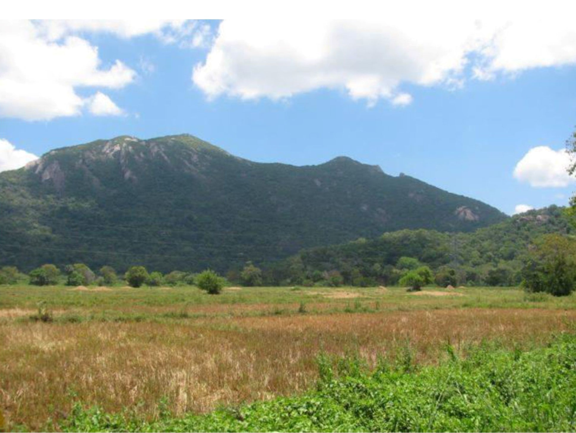
Six. Very important to note is - Wasgamuwa National Forest in Sinhala stands for Battlefield and is believed to be the place where Ram - Ravan war was fought .
This is the plain area on the northern tip of the mountainous terrain.
Certianly Ravan would not have allowed Shri Ram to enter his kingdom deep enough into his territory. Rather No defender allows the enemy to enter his territory.
This indicates that Ravan’s army fought Shri Ram’s army somewhere very close to the border of his kingdom.
This also implies that Ravan's kingdom was around this Hilly region and down further South.
Seven. When we correlate the folk lores related to Ravan in Srilanka WITH the places/ sites that are associated with him we can surely form a general lay out of Ravan’s kingdom. Thence lets have a look at such places/ sites One by one.
A. Ritigala .
- This is the Highest Hill in Northern srilanka. It is approx 2153 feet and almost 6 kms in length. It is 156 kms from Mannar.
- According to popular belief, Hanumanji traveled over Ritigala, and, by accident, dropped a chunk off a mountain which had medicinal herbs of the Himalaya range he was carrying from India to Lanka.
- Astonishingly, There is a pocket of vegetation of healing herbs and plants at the strange mini-plateau at the summit of Ritigala, which is distinct from the dry-zone flora of the lower slopes and surrounding plains at Ritigala.
- One of mysterious aspect is the belief of powerful medicinal herbs found near the crest. A herb called “Sansevi” is believed to have the power of conferring long life and curing all human pain. According to legend, all vegetation on Ritigala is protected by Yakkas.
- Another folk lore about Ritigala is ; after Having found the location of Sitaji , Hanumanji made use of Ritigala as a launching pad to take a leap across to Kishkindha. Arishtgiri mountain is mentioned in Sundarkand from where Hanumanji took the flight back. So, whether Arishtgiri is the Ritigala or not can not be ascertained. Incidentally, Ritigala is the highest prominent hill between the central plains of Sri Lanka and the coast of southern India.
- However, In Buddhist literature Mahavamsa chapter 10 and 21 there is a mention of a mountain Arritha parvta which might have been called as Arisht giri by Valmiki. As per some in Srilanka- Ritigala was known by the name of “arittha-pabbata” during the reign of Pandukabhaya (377-307 BC), the third king of Sri Lanka.
- Suvel Parvat as per Valmiki’s Ramyan( Refer to Yudh Kaand) is the hill where Ram spent the night in Lanka. Lankapuri was visible from Suvel parvat and it appeared to be in the sky.
- So, this implies that Ravan's Lankapuri and the dancers' adoring precious jwellery at night should have been visible from Ritigala. It is a mountain in central Srilanka which is home to an ancient Buddhist monastery. The ruins and rock inscriptions of the monastery date back to 1st century BCE. It is located 43 km (27 mi) away from the ancient monastic city of Anuradhapura.
- Sigiriya Palace, is a magnificient Rock palace on a Huge rock , literally jutting into sky is approx 20-30 kms from RITIGALA. There are hardly any intervening features between Ritigala and Sigiriya and it is quite possible that Lights at night at Sigiriya Palace could be observed from Ritiagala.
9. So Ritigala may be the hill that could be the Suvela parvat of Valmiki where Shri Ram spent the night and saw the glittering lights of Ravan’s palace at Sigiriya which appeared to be touching the sky (Yudh Kaand Ramayan ). But Ritigala has been mentioned as Arisht or Arritha Parvat in two old texts ; Ramayan and Mahavamsa.
10. Sigiriya Palace is a world heritage site and Ritigala is a famous Buddhist Center.
11. Mannar to Ritigala is 156 kms and so Shri Ram's army would have taken atleast 5 -6 days to reach here.
12. Ritigala being a huge dominating feature, it could have served as a SECURED Firm base for the army that had travelled almost 150 kms into enemy's teritory. But because it is the Arishtgiri mountain, we have to over rule this as SUVEL PARVAT.
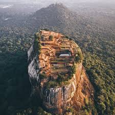
B. Sigirya ; Is A World Heritage Site (Refer to Map Below).
- It Has A Magnificient Palace On A Huge Hill In Srilanka. It Is Also Called As Alka Nagri. It is a site of historical and archaeological significance that is dominated by a massive columnof rock around 180 metres (590 ft) high.
- It is said King Kashyap(477 – 495 AD) built his palace on top of this rock and decorated its sides with colourful frescoes. On a small plateau about halfway up the side of this rock he built a gateway in the form of an enormous lion. The name of this place is derived from this structure — Sīnhāgiri, the Lion Rock.
- Sigiriya is considered to be one of the most important urban planning sites of the first millennium, and the site planis considered very elaborate and imaginative .
- King Kashyapa had moved the capital and his residence from the traditional capital of Anuradhapurato the more secure Sigiriya.
- After the loss of King kashyap im a war the Sigiriya was complex was developed as a Buddhist monastery and thereafter as an Out post for kandy Kingdom.
- Sigiriya is considered to be one of the most important urban planning sites of the first millennium, and the site planis considered very elaborate and imaginative.
- On the west side of the rock lies a park for the royals, laid out on a symmetrical plan; the park contains water-retaining structures, including sophisticated surface/subsurface hydraulic systems, some of which are working today.
- Five gates were placed at entrances. The more elaborate western gate is thought to have been reserved for the royals. One historian wrote, "The whole face of the hill appears to have been a gigantic picture gallery... the largest picture in the world perhaps". The paintings would have covered most of the western face of the rock, an area 140 metres long and 40 metres high. There are references in the graffiti to 500 ladies in these paintings. However, most have been lost forever.
- The true identity of the ladies in these paintings still have not been confirmed. There are various ideas about their identity. Some believe that they are the ladies of the kings while others think that they are women taking part in religious observances.
- Originally this wall was so highly polished that the king could see himself whilst he walked alongside it. Made of brick masonry and covered in highly polished white plaster,
- The Gardens of the Sigiriya city are one of the most important aspects of the site, as they are among the oldest landscaped gardens in the world. The gardens are divided into three distinct but linked forms: water gardens, cave and boulder gardens, and terraced gardens.
- Ritigala and Sigirya are barely 20-30kms apart and both are dominating features. Sigiriya Rock provides defender a huge tactical advantage. Lets have a look at Sigiriya..
.
In the background one may notice the Ritigala where perhaps Shri Ram's army was camping. It is to my mind unlikely that someone all of a sudden would develop this Rock Hill jutting into space as a Palace, unless something already existed there. Just have a look at the Top view/ aerial view of Sigirya Palace.
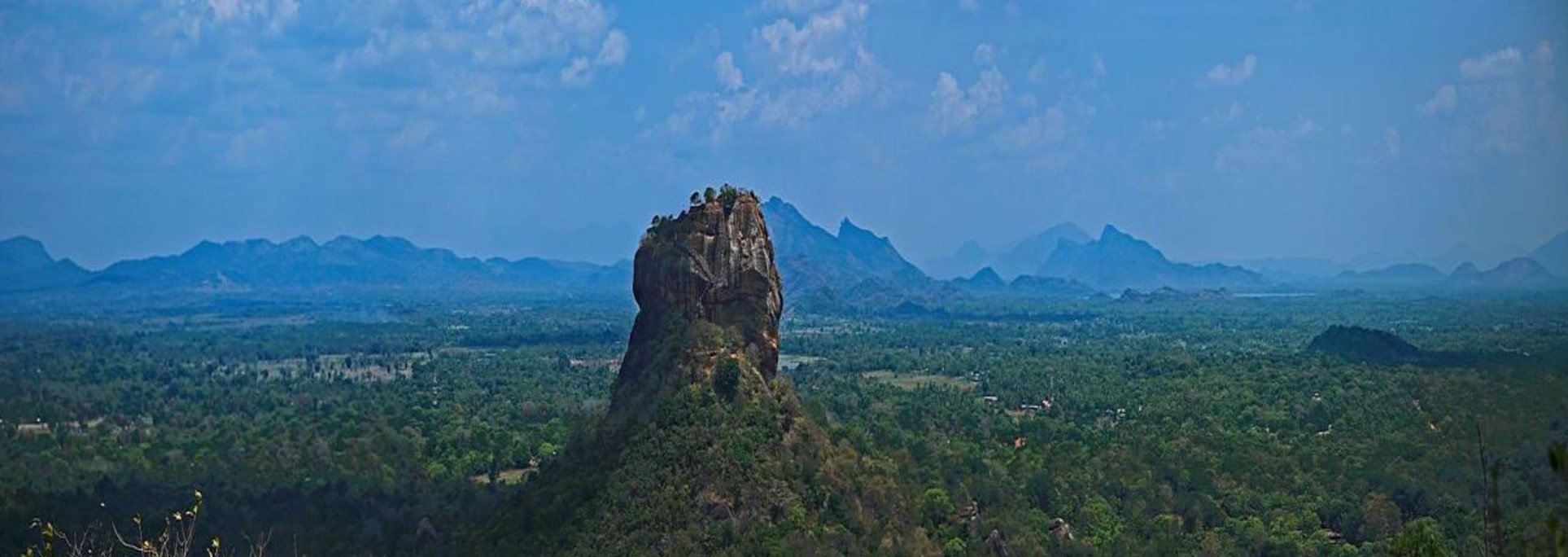
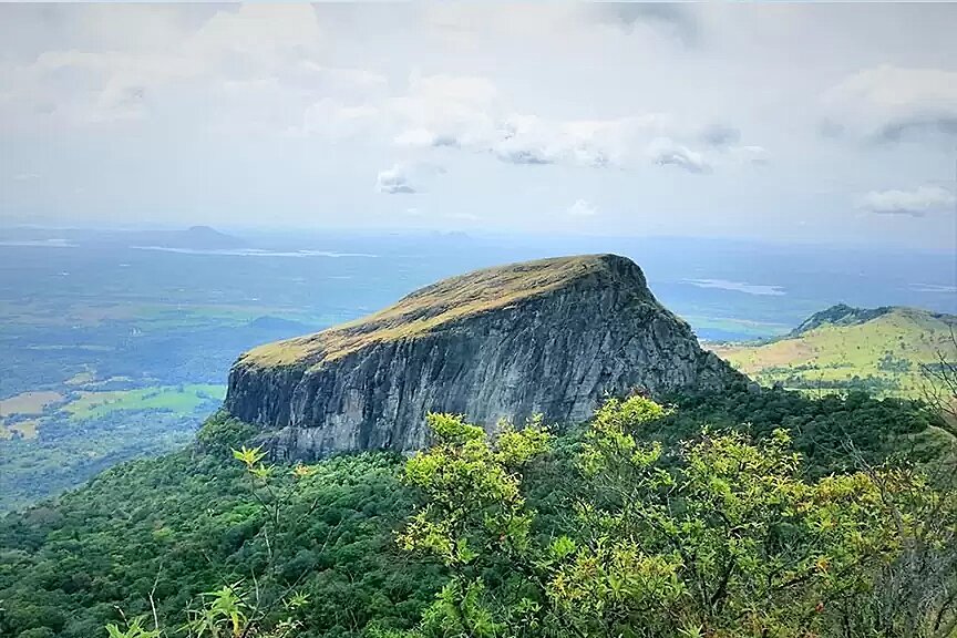
C . Laggala –
- Laggala or lake gala or ellaka gala is a prominent rock from where Rama’s army was sighted for the first time before the final battle that took place near this rock , today located inside Wasgamuwa National Forest. Wasgamuwa in Sinhalese language means Battle field.
- Laggala is derived from the Sinhala term “Elakke Gala”, which means Target Rock as it was from here Ram’s army was sighted. It is geographically located in the highest part of the northern region of the country.. Laggala served as a sentry point of Ravan’s kingdom to observe Shri Rama’s army.
- This can be termed as the highest part of the northern region of Rāvana’s city.
- This tall and magnificent, the Laggala rock, also known as Lakegala, Lankagiri, is located near Dunuwila.
- Laggala is a part of the knuckles range which has prominent 5 peaks , may be from some angle only three peaks are visible. Hence the knuckle range might be the Trikatu Parvat of valmiki mentioned in Yudhkand.
- Since it sits almost in the centre of the country and forms the tail end of the Dumbara Hills (Knuckles Mountain range), Laggala might have served as an OBSERVATION OUT POST for Ravana’s army. Therefore any advancing army from Riti gala or Sigirya could be observed from Laggala.
- The rock is said to be ALSO a place where Shri Rama killed King Ravana with the Brahmasthram weapon from Dunuwila. It is significant because it was the point where the war begun and also where the final battle took place.
- Dunuwila is a place from which Shri Rama fired the Brahmastra at king Rāvana who was directing the war from Laggala, where he was killed. In Sinhala language 'Dunu' means bow and 'Wila' means lake.
- But Dunnuvila is a plain and almost 50 kms from Laggala , how could Ram fire a bow and kill Ravan from here?
- There is a famous mountain range called Knuckles Range. The range although consists of Nine peaks but from certain locations only five are visible resembling the knuckles of a closed fist, when viewed from certain locations in the Kandy district .Now its quite possible that if viewed from a certain direction only three peaks might be visible and hence Valmiki called it as Trikut Parvat where Ravan’s palace was located. This knuckles range has some of the highest peaks of Srilanka. And that’s why his palace appeared to be touching the sky. In Sundarkand THERE is a description of a mountain that Hanumanji saw that was strange with many peaks when he came to Ashok Vatika.
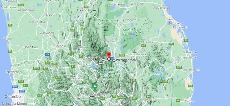
D. Werangatota/SitaKotuwa/Sita Eliya.
- In Sinhalese Werangatota means Landing Ground. Valmiki could not have named this as Landing ground, because he would not have had an idea where did Ravan's aerial vehicle had landed, yet there is a story around this place.
- It is believed that Ravana brought Sitaji to Sri Lanka by an aerial vehicle called 'Pushpaka Vimanam' by the Hindus and 'Dandu Monara Yanthraya' by the Sinhalese.
- According to local folk lore, this vehicle landed at Werangatota, about 10 km from Mahiyangana, in central Sri Lanka. Sitaji was then taken to Goorulupota, now known as Sitakotuwa, closer to Ravan’s Palace.
- Sita Eliya. Later on Sitaji was shifted to a place which had great scenic beauty Sita Eliya closer to Kandy. There is also temple for her there. She is believed to have bathed in the mountain stream flowing beside the temple. This is the place where Ashok Vatika was located and today it has a wonderful Botanical garden, called Hakgala Botanical Garden. The flora and fauna of the place resembles what Valmiki described in his Ramayan. It is believed that Hanumanji met Sitaji in thsi garden.
- In Valmiki’s Ramayan also there is a description that Hanumanji saw a high mountain and caves near Ashok Vatika. Hakgala has a few caves where it is locally believed that Ravan lived in one of those which is close to the waterfall.
E. Wasgamuwa National Forest.
1. In Sinhala language it means Battle field. It lies near the ancient city of Polonnaruwa, which has historical ruins in abundance. The name Polonnaruwa is of unknown origin and was adopted by the some western traveller . Its Tamil form, Pulainari, is mentioned in Tamil inscriptions found at Polonnaruwa of the Chola period. The name was perhaps a contraction of its ancient name Pulastya nagara or Pulatti nakaram meaning city of the Hindu sage Pulastaya. Polonnaruwa was first established as a military post by the Sinhalese kingdom. Ravan’s grand father was sage Pulastya.
2. Ruins of ancient irrigation tanks of Malagamuwa, Wilmitiya, Dasthota and Yoda Ela canal which were built by Parakramabahu 1 are found within the park. The famous battle ground of the final battle between Chola King Elara and Sri Lankan King Dutugamunu, Yudangana Pitiya, and the supposed camp site of King Dutugamunu’s army, Kandaura Pitiya, can also be visited here. It also has, besides the Brahmanic monuments built by the Cholas, the monumental ruins of the fabulous garden-city created by Parakramabahu I in the 12th century.
3. The historical importance can not be undermined and so its important that a proper Scanning of this forest is undertaken.
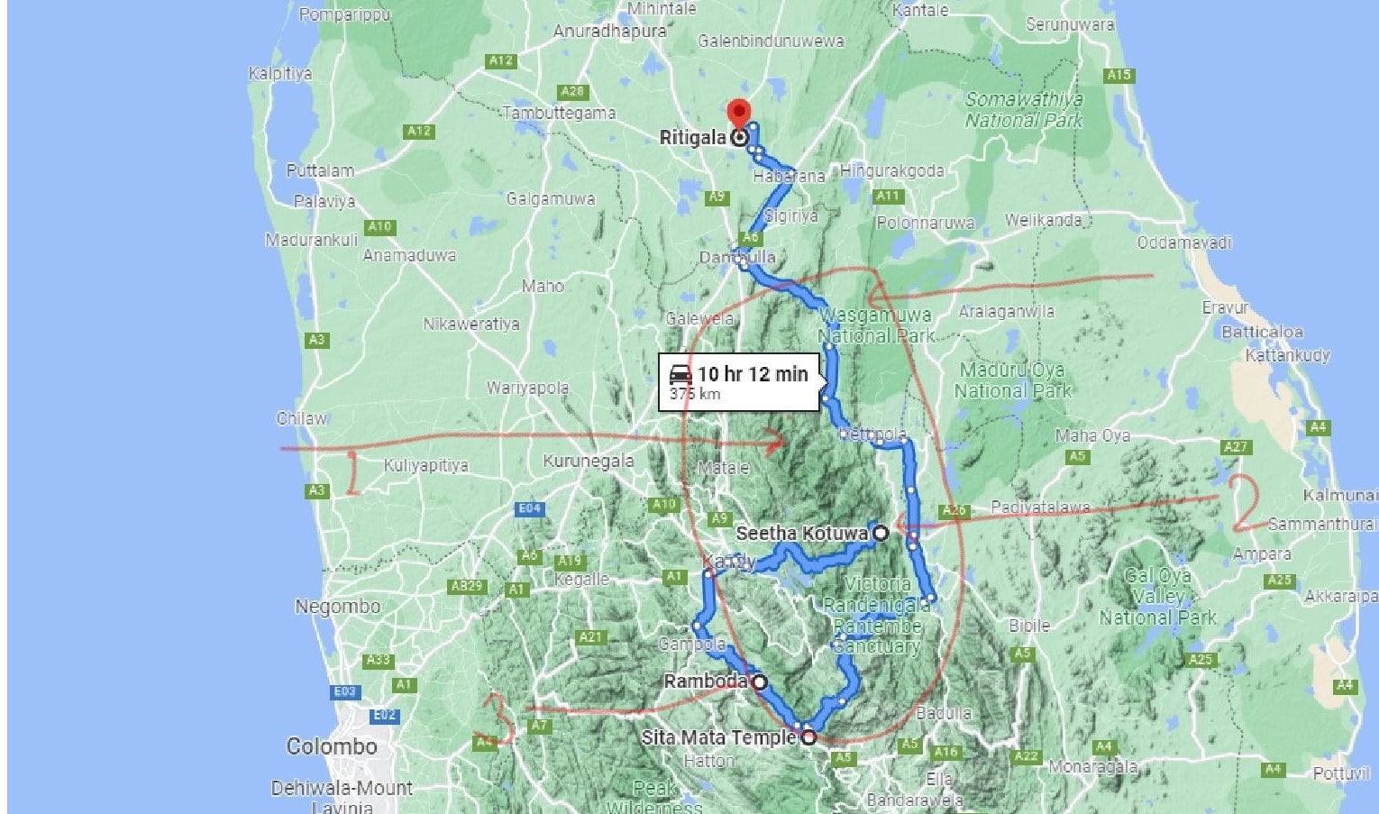
For above details refer to Map Below ;
Sigiriya - 1
Wasgamuwa National Forest (Battle Field ) - 2
Weragantota (Landing Ground )- 3.
Seeta Kotuwa (Where Sitaji was kept initially closer to Mandodri's Palace - 4.
Knuckles Range (Mountain with many Peaks ) - 5
NuwaraElliya ( Place where Sitaji was moved later on , called as Sita Elliya where it is believed Ashok Vatika is located - 6
MAP 2
F. Other places related to aerial vehicle are ; Wariyapola in Mattale meaning landing ground, Thotupola meaning a port or a place where one touches down in a journey.Goorulupota in Sinhalese mean ; parts of bird , implying this place was also related to the aerial vehicle , may be its workshop/repair center is closer to Werangtota whereas rest of the places are a bit towards FURTHER South of Kandy.
G. Yahangala.
1. After Rāvana’s death, his body was kept on this Rock, which means in Sinhala language as Divan or Bed Rock for the country men to pay their respect for their departed King.. His body is said to be hidden on the left side of the rock.
2. This rock gives beautiful 360 degree views of the surrounding landscapes. The rock boulder is believed to have been the hallowed adobe of Arahats in ancient times. This rock boulder has equal dimensions, which legend says was the act of the Arahats who had taken abode there.
3. During the time of Srilankan King Gajabahu’s reign in the 1st century AD, there was a province called Keliyapura Nuwara close to Yahangala. The shape of this rock is unique and striking. It is called Bubulakara –a bubble shaped dagoba.
4. Steps have been carved out on the rock believed to have been made in ancient times. The place is deserted and the dagoba is overgrown with creepers. Among the archaeological artifacts found at the site are stone-carved Buddha statue minus its head, stone pillars, scattered among its ruins. Fading Brahmi inscriptions are believed to have been carved on a rock near the flight of steps.
5. Although one may feel that given the steep climb and difficult climb to the top it makes little sense to keep his body on top for countrymen to pay respect. But it is quite possible that there might have been a temple there and the stairs to the location already existed.
H. Ravan Caves.
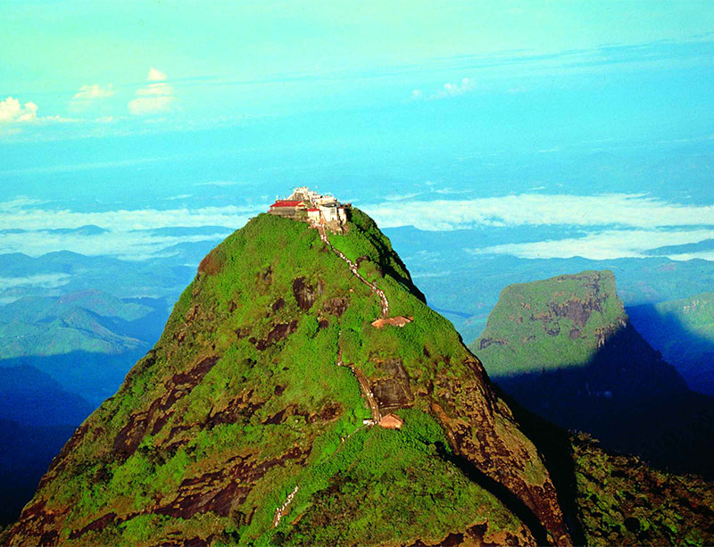
- Valmiki writes in Sundarkand that when Hanumanji landed at Trikut parvat he roamed around looking for Sitaji . He moved around the Lankapuri city and then came to a strange mountain which had many peaks and caves. This mountain was near Ashok Vatika.
- If Ashok Vatika is the same place as Hakgala Botanical garden then the strange mountain could be Pidurutalagala which has a very prominent peak. It is the highest mountain in central srilanka and also one amongst the ultra prominent peak. Pl see the pic.
- In addition Valmiki talks of many caves. It is reported that a network of caves have been found in this mountainous region and if one believes the folk lores they were made by Ravan. A team needs to verify that these caves are interconnected.
- The tunnel mouths are situated at ; 1. lsthripura at Welimada, 2. Bandarawela, 3. Sena pitiya at Halagala, 4. Ramboda, Labookelle, 5. Wariyapola / Matale and 6. Sitakotuwa/Hasalaka.
MAP 3
I. Pidurutalagala,
- In Sinhala means Straw Plateau Rock, or Mount Pedroin English, It is an ultra mountain peak and the tallest mountain in SRI LANKA at 8,281 ft It is situated in North-North-East of Nuwara Elliya and is easily visible from most areas of the Central Province.
- In Sundarkand there is a description of a strange mountain with many peaks that Hanumanji sees from Ashok Vatika which is near Nuwara Elliya.
- Pidurutalagala is one of the 1500 ultra mountain peaks of world and part of Great western mountain range. Have a look at this strange peak.
- It is a part of Kandayan mountain range.
J. Other sites/Places .
- Ussangoda was used by Ravana to land hisPushpak vimana, a flying chariot. Ussangoda has very unusual soil. Some believe that the soil is natural black because the place was hit by a meteor whereas some believe that the soil is black as a result of ashes that stayed back when Lanka was set on fire by Hanumanji.
- Unawatuna, is near the present Galle harbour. Unawatuna means 'here it fell'. The area is known for its medicinal plants, it is believed that the mountain that Hanumanji carried , a piece from that fell here.
- Rummasala Hill. Barely 2 kms from the village Unawatuna is the hill where it is believed that the pieces of the mountain fell.It is difficult to explain number of intriguing features of the Rumassala Hill. The place is considered to be a haven for herbs, with researchers having found and recorded 150 different species on the hill. The herb locals refer to as ‘Kalu Nika’ is even believed to have life saving properties. The identified herb species are unique to the hill, and don’t grown anywhere else in the vicinity. One possible explanation is that the soil properties of the hill are inherently different to the surrounding landscape – supporting the Ramayana legend that it was transplanted from a completely different geographical location. According to Arthur Clarke, renowned science fiction author, Rumassala has one of the lowest gravitational fields on earth, resulting in satellites being lost in orbit when they pass overhead.
- Kelaniya . Sinahalese people consider Vibhishana as one of the four guardian deities of ceylon.This belief was more prominent in the Kotte According to the Ravana Kathaof Wickramasinghe Adigar, after the defeat of Ravana, Vibhishana transferred the Yaksha capital from Alaka mandawa to Kelaniya . He continues to be worshipped by a few adherents, mainly in the Kelaniya area. In 1909, Henry Parker states in his book Ancient Ceylon that, "the four Guardian Gods (Hatara Waram Deviyo) of Ceylon are;
Saman 'Divya Raja' in the east, Skanda in the south, Vishnu in the west - he is said to have delegated his powers to Vibhishana, the Rakshasa king of Ceylon, who is now treated as a god in the Western Province - and Ayiyanar (called also by Low-Country Sinhalese, Boksal), in the north."
There is also a lesser-known folklore among rural communities in the North Central Province, that King Dhathusena's son Mugalan was Vibhishana. Once Kashayapa was crowned as the king, Mugalan fled to India. He returned to Sri Lanka with a foreign army. It is said that Vibhishan had demon-looking eyes (a stare) and once he returned to Sri Lanka with a powerful foreign army, he was titled by the locals as Vibhishana or the 'terrible one'.
5, Ramboda . This is the place where it is believed Hanumanji first set foot in Sri Lanka . Ramboda is 35 km away from Nuwara Eliya, there is a Hanuman temple at this place. Opposite the temple is a mountain range known as Ravana boda” , it is believed that Ravan’s army was at Ravanboda and Hanumaji’s army was at Ramboda, between the two mountain ranges flows the Mahaweli Ganga river, in the valley down below. It was in this valley, it is believed that the two armies fought.
Note ; For Map Below
1. Pidurutalagala.
2.Ussangoda.
3.Unawatuna and Rumassala.
4. Kelaniya
5. Ramboda
MAP 4
Few Clues from Sriankan ancient literature.
The recorded history of srilanka starts from the arrival of King Vijaya in 500 BCE so what was happening in Srilanka before his arrival one can only learn from folklores or ancient Sinahlese literature like Mahavamsa and what other foreign historians have written.
Srilankan history also therefore has same challenges as the Indian history faces. India's recorded history starts from Alexander’s invasion and there is hence a gap of almost 2000 years ; Indus Valley civilization to the Alexander’s invasion that is often filled with the help of ancient literature and folk lores.
Few important aspects from the Srilankan ancient literature that can help us are ;
- In Mahavamsa poem of Sri Lanka, Several different indigenous clans lived in the island of Srilanka during the pre-Vijaya era (before 505 BCE). These clans and the mystical kingdom of Lanka were mentioned in the great epics of Mahavamsa and Vargapurnika.
- There has always been a cultural and religious give and take relationship between South Indians and native Srilankans who many of them adopted Buddhism after Emperor Ashok’s son visited Srilanka.
- So, even Buddhist texts mention that ; The four clans Yakkha (Yakku), Naga, Deva, and Rakkha (Rakus) inhabited Srilanka.
One. Yakkha people were believed to inhabit in the mountains where they had used monsoon wind to mold iron because the Elu derivative of the word (yakka) means Iron.
Two. Rakkha people were supposed to be farmers who used the steel products of the yaksha people in their farming endeavors (the name Rakkha or Raksha is derived from the two syllables ra + kus, in Sinhalese Kus means "stomach"; and ra meant "to protect". Thus, rakus literally means the people who fulfill hunger or the people who provide rice, the staple food of the people),
Three. the Naga people were believed to be traders,
Four. the Deva people were the rulers, the people who used to be the link between the Raksha people and yaksha people
- The era before the arrival of Prince Vijaya was not well documented so there is not much known of the previous native rulers of Sri Lanka. Ravana the mythical king of Lanka kingdom is considered the most famous and most powerful native king who ever reigned in Sri Lanka from Rakkha or Rakshasa clan.
- King Vibheeshna, King Mani Akkhitha, King Mahodara were some kings from Naga clan. King Sumali, King Malyawan were famous kings from Yakkha or Yaksha clan and Sumana Saman was a king from Dewa clan.
- Another story that I came across was that The Veddha community are the indigenous people still living in Sri Lanka. Most speak Sinhala instead of their indigenous language which is nearing extinction. The Veddahs were probably the earliest inhabitants of Sri Lanka and have lived on the island before the arrival of other ethnic groups from India. The Ratnapura district, which is part of the Sabaragamuwa Province, is known to have been inhabited by the Veddahs in the distant past. The very name ‘Sabaragamuwa’ is believed to have meant the ‘village of the Sabaras’ or ‘forest barbarians’. Place names such as Vedda-Gala (Vedda Rock), Vedda-Ela (Vedda Canal) and Vedi-Kanda (Vedda Mountain) in the Ratnapura district also bear testimony to this.
- The Nagas of pre-Vijayan Lanka were believed to have lived around Kelaniya and in the peninsula in the North. Nagadeepa (Nainathivu) was an island off the peninsula joined to the mainland about 30 years ago by a causeway. The 'nagas' confined themselves to the Coastal region ; extending from Kelaniya to Nainathivu. King Vibheeshan had shifted his capital after coronation to Kelaniya.
- The 'yakkas' were numerous and very powerful, and confined themselves to the mountain region of the North- Central Srilanka, The luxuriantly wooded Mahanaga garden, on the right-bank of the river Mahaveli Ganga, was the stronghold of the 'yakkas'.
- The King of Yakshas, Vaisravana (also known as Kubera or Kuvera) and the Rakshasa king, Ravan, were both sons of the sage Vishrava, son of the great Rishi Pulastaya from two different wives. Kubera is sometimes mentioned as a Rakshasa king also. Kubera ruled a Yaksha kingdom of enormous wealth.
Deductions.
Having gone through the folklores as they exist in Srilanka, the places associated with Ram and Ravan in Srilanka and offcourse Valmiki's Ramayan, the following clearly stand out ;
- Ravan who came from Yakkha / Rakkha clan must have ruled a Kingdom that was located in mountains. As Ravan had snatched the Kingdom from Yakkha ruler Kuber who lived in mountains.
- Valmiki’s Ramyan also describes Ravan’s Lankapuri located in mountains that appeared to be touching the sky.
- In Sundarkand also there is a description at number of places of Hanumanji landing at Trikatu Parvat and having seen a strange mountain peak and caves.
- So, the Lanka puri must have been in mountains.
- The places like Lagagala , part of Knuckles Range having numerous peaks where Ravan had an out post and was believed to have been killed (marked as 1 in the map below) Werangatota (landing ground where Ravan landed with sitaji in his Pushpak Viman , Sita Kotuwa where Sitaji was kept initially near Mandodri’s palace (Marked as 2 on Map), Sita Eliya near Nuwara Elliya where Sitaji was shifted , , Ramboda where Hanumanji landed first, Ravan boda, the Wasgamuwa National Forest( battlefield), the Valley of Mahvelli Ganga between Ramboda and Ravangoda where Hanumanji and his troops fought with Ravan’s troops, (Marked as 3 on the map) fit the story as mentioned above.
- Thus the area that falls within the circle marked in red is the one where if a dedicated team carries out search, there is a strong possibility that one may find some evidence that may go a long way in proving that the story of war between Ram and Ravan is true.
- Given the rudimentary nature of weapon systems that both the armies were possessing and very limited observation / surveillence systems available with them (when one reads Valmiki’s Ramayan one notices that the weapons used by Sugriva’s army were rudimentary ; the monkeys threw Trees, branches, big stones at the enemy and Sugreeva and Ravan even had a wrestling bout ) , it is very likely that the battle must have been fought for days in an area within or close to the circle marked in Red.
- Moreover, Hanumanji knowing the area where Sitaji was kept must have been clearly told to straight head for that area i.e Sita Eliya near Nuwara Elliya and rescue Sitaji from the clutches of Ravan. Hence Ramboda and Ravanboda in that sense are important sites.
MAP 5
9. The map 3 also indicates that Ravan's cave network is believed to be in and around this area which have surprisingly not been explored fully.
10. It is quite intriguing why names of certain places are named in Sinhalese language that are related to Aircrafts ; Landing GroundWariyapola, Werangatota) Goorulupota in Sinhalese mean ; parts of bird , implying this place was also related to the aerial vehicle , may be its workshop/repair center. One does not find such names in India.
10. Having been part of IPKF in late 80s i noticed that Srilankan Jungles are very dense and largely unexplored. May be in these last 30 years things must have changed but may be a dedicated team will be able to unearth something important.
It is also important to arrive at the era/period in which Ram-Ravan war was fought because that will also ascertain the kind of equipment the two armies might be using ;
One. The Bronze age in India was from around 3000 BC to around 1500 BC , This was the period when Indus civilization flourished , thereafter from around 1500BC it was the beginning of Iron age. When one visits the Indus civilization sites one finds artefacts made of bronze and not of iron. It was in Vedic period that Iron got introduced. So, when Ramayan as an epic, involved characters from the Vedic period, the Ram -Ravan war must have been fought after 1500 BC. Had it been fought in 5000 BC then the Chariot would have been without any metal and arrows must have had a chiseled stone as the pointed end and Hanumanji's Gadda must have been made of stone.
two,. A 6th century Ramayana manuscript kept in Calcutta at a Sanskrit library has only 5 kandas instead of 7 and this Ramayana does not begin with the curse that drove Dasarath to send Ram into exile. This implies that there are many versions of Ramayan which might be having conflciting or varied information. Valmiki's Ramayan , however does make a mention that the Sugreev's and Hanumanji's army men threw Branches and stones at Ravan's soldiers and Sugreev even had a wrestling bout with Ravan.
three. The Rigveda records an early stage of Vedic tradition. Given the fact that Rigved eulogizes Saraswati River which it describes as a giant river and now the research has proved that by 1800 BC it was a dying river so Rig ved must have been written before the River Saraswati died and so Ramayan could not have been written before Rigveda i.e BEFORE 1800 BC. Although there are claims by various sanskrit scholars that Shri Ram has been mentioned in Rigved but there is no direct indication.
four. Ramayan mentions Ayodhya as the capital of Kosala Kingdom, rather than Saketa or Shravasti. As per Jain and Buddhist texts and other literature the Capital of Kosala was Saketa , another ancient name of Saketa was Shravasti as per Buddhist texts. It was only in 4th century that Ayodhya as capital of kosal or magadh was used. So, does that mean after the Buddhist influence weaned that Saketa or Shravasti was renamed as Ayodhya. There is hence a scope for further research work on this and possibly more excavations may reveal the truth.
In view of all the above, the dates as mentioned by Mr Pushkar Bhatnagar in his Book ; Dating Lord Rama’s era may appear to be unrealistic.
So, once again it is reiterated that there is a strong possibility that something worthwhile can still be found in the area marked in RED CIRCLE in the Map 5.
To be Continued.